|
Articles
Navigating Portland
Portland Public Transit: Trains, Buses, Streetcars Living in Portland Without A Car Finding an Apartment or Rental in Portland Where in Portland should I live? Random Facts and Portland Trivia Portland Frequently Asked Questions Portland Grocery Stores Top 5 Things To Do Before Renting a Place in Portland Area Descriptions Downtown/Northwest
Downtown
Goose Hollow and King's Hill Northwest Portland Riverplace South Waterfront The Pearl District Northeast/North Portland
Alberta
Beaumont-Wilshire Hollywood District Irvington Lloyd District Mississippi St. Johns University Park Southeast Portland Southwest Portland Suburbs/Outlying Areas
Beaverton - West Suburbs
Lake Oswego - South of Portland Orenco Station - Hillsboro Tanasbourne - Hillsboro/Beaverton Tualatin Town Center - Southwest of Portland Vancouver, WA Links Portland Scenic Photographs by Andrew Hall
Craigslist - Great for rentals OregonLive.com - the Oregonian Online |
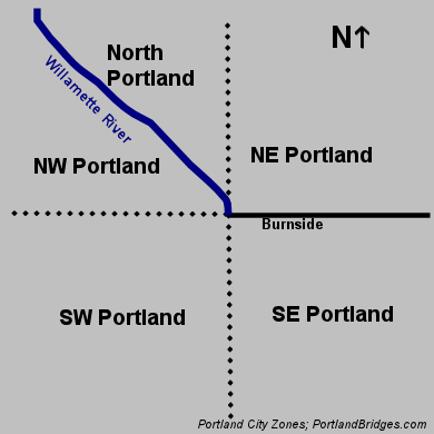
[For Portland public transit info, see Portland Public Transit: Trains, Buses, Streetcars ] Portland is divided down the middle by the Willamette River (pronounced "will-AAAH-met", the "AAAH" sounds like "cat") into East and West. Burnside Street similarly divides the city into North and South. As you might guess, this produces four quadrants of town: Northeast (NE), Northwest (NW), Southeast (SE), and Southwest (SW) Portland. However, the river curves a bit to the west north of downtown, and this makes for a weird fifth "quadrant" that is called North Portland. The addresses in each of the sectors are abbreviated with the N, NE, NW, SE, or SW in front of the street. In Portland, "avenues" run north to south and are usually numbered (except in North Portland and parts of NE and SW Portland). "Streets" run east to west. Numbered avenues ("1st Avenue") appear in NE, NW, SE, and SW but not in N Portland. The same avenue numbers appear on both sides of the river. There's a NW 10th Avenue and a SE 10th Avenue - both on opposite sides of the Willamette River, and they never meet! But SW 10th is a continuation of NW 10th, because avenues run north to south. Don't worry, it sort of makes sense once you get used to it! You can tell which side of the street an address is on by whether the street number is odd or even. Even numbers are on the east side or north side of the street; odd numbers are on the west side or south side of the street. For example, 101 SW 1st Avenue would be on the west side of SW 1st Avenue, in the SW section of town. 102 SW 1st Avenue would be on the east side of SW 1st Avenue. Seventeen city bocks is about one mile. Portland has a good number of one-way streets, mostly downtown. One driving tip on a matter that confuses newcomers and tourists: it is legal to turn left onto a one-way street at a red light (just like it's legal to turn right on red). This greatly helps you navigate Portland's one-way grid downtown; because of the way the stoplights are timed, if you wait until green to turn left, you'll immediately hit another red light. Even more tricky, you can turn left on red from a two-way street to a one-way street (but not the other way around!). Many Oregonians do not even realize this is legal. Street parking in many Portland neighborhoods is free, except for downtown, the Pearl, and the Lloyd District, which has parking machines (you purchase a sticker to put on your car for the time you need) instead of parking meters, mostly. On busy streets, there are often green and white "One Hour," "Two Hour," etc. signs to limit the amount of time you park in front of retail businesses. However, these signs are only enforced (unless otherwise indicated) during the hours the parking machines/meters are enforced. So on a Sunday, for example, or after 7PM weeknights, you can park indefinitely in one of those "One Hour" parking zones. Portland's Major FreewaysThe I-5 freeway forms a loop around downtown Portland with the short I-405 freeway. There is no freeway going directly through the center of Portland. The southern end of I-5 below downtown Portland runs through a treacherous area called the Terwilliger Curves; traffic really trends to backup on these curves in the morning. At the northern end, into Vancouver and the state of Washington, traffic is heavily constricted by the regular lifts of the Interstate Bridge. I-84 (sharing US 30 on the map), nicknamed the "Banfield Freeway" or just the "Banfield," is the major east-side freeway. The Banfield can be backed up in either direction at any time of the day. US 26, nicknamed the "Sunset Highway," is the major freeway to the west side of Portland, out to Beaverton and Hillsboro. The Sunset burrows through the hills via the Vista Ridge Tunnel (three lanes each direction) and then heads west straight uphill for a few miles; at its peak, Sylvan, you may see snow on cold winter days when it's only raining elsewhere in town. As the population on the west side of town has exploded, the Sunset has become super congested, and construction has been underway for years to widen it. Inbound into downtown in the morning, this highway is just terrible. In fact, inbound can be bad at night, too, against rush hour traffic - and if there is an accident in the tunnel or elsewhere, forget it - get out a book. On the east side, I-205 provides a long bypass around the city, from Tualatin all the way up to north of Vancouver, WA - also servicing the Portland Airport. On the west side, there is no such bypass; instead, OR 217 provides a short, congested shortcut from I-5 to US 26 through Tigard and Beaverton.
Have a question about Portland that isn't answered here?
Next: Portland Public Transit: Trains, Buses, Streetcars Articles Frontpage Downtown/Northwest NorthEast/North SouthWest Suburbs/Outlying Areas
|
 Frontpage/Areas Map